There are two types that support the creation of a highway model, the Track and Bridge types. The Track type is used to specify a road highway asset. For example: two lanes of a road
This example is for a 2-lane highway:
length             5
width              7.9
kind               "track"
type               "Roads"
carrate            25
asset-filename     "road"
istrack            0
isroad             1
isfreeway          1
numlanes           2
Length: indicates the length of the track for the lane
Carrete: creates a density of traffic in one second, the density must be greater than 3, Note: the higher the number, the longer the time to create a vehicle.
Istrack: Determines whether it is a railway track or not
1 = traincars use asset,
0 = disables this option.
Isroad: Specifies that this is a road.
1 = generate traffic,
0 = suppress traffic. See also carrate mark.
Isfreeway: This setting indicates:
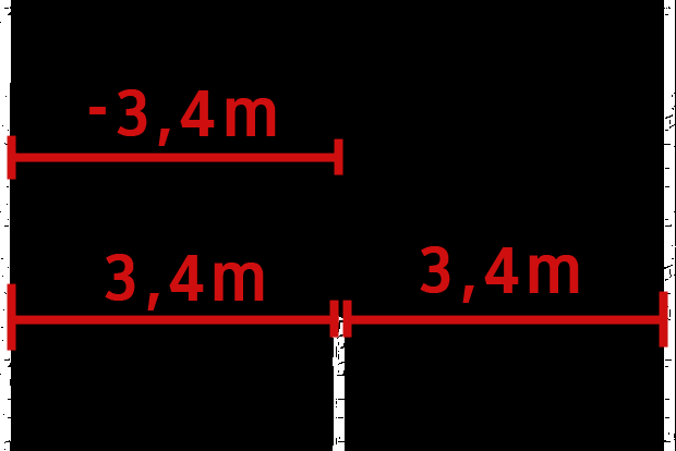
If it is 1 – creates highway traffic, 0 – determines road traffic, then the setting is -3.4; 3.4 m
Numlanes: determines the number of highway traffic lanes 2;3;4;… (the system is set to a 3.4m lane)
Trackoffsets: on either side of the bridge centerline where the road will be connected.
A note about a single road must be connected on the axis of the bridge, a small offset of 0.01, must be entered.
Trackdirections: Specifies the direction of traffic for each of the vehicles connected to the bridge,
0 = one-way traffic for dual lanes connected at -3.5m,
1 = right to flow in opposite direction for double lanes placed at 3.5 m.
Height: This value defines the use of the object:
0 = the object is a double track, a negative value (-) means the object will be a bridge, a value of -12 for example is the height from the deck to the bottom of the foundation bridge, a positive (+) means the Object is a tunnel, a height of 8 is for example a portal height tunnel.
Bridgetrack: highway, road kuid to be used on a bridge – two lanes of highway, located on either side of the bridge centerline at the indicated offsets. This connected road to be used on the bridge requires a freeway setup, as in example 1 above, it functions as a freeway.
category-class                          "SR"
kind                                    "track"
istrack                                 0
isroad                                  1
traffic-speed                           30
visible-on-minimap                      1
isfreeway                               0
carrate                                 5
mesh-table
{
default
{
mesh "SWR2.im"
auto-create 1
}
}
track
{
mesh-length 12
track-lod-tree
{
lod-distance 3500
mesh "default"
}
}
kuid-table
{
}